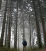
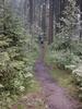
Black Forest in the mist
6/26/98, 9:30. On a bench just past the Gasthof zum Kreuz. We got started at 8:30 today because I had to repack the backpacks, getting the rain gear out. It started raining yesterday at 5:00 and rained on and off all night. Today it is drizzly and overcast, actually doesn't feel bad after the heat yesterday. The only problem is that because of the rain I have to wear my boots rather than sandals.
11:00, Redeckhof. Somehow we got off the Westweg and ended up here. I think I can find our way back. Actually, the area is beautiful, with small farms interspersed with woods of evergreens.
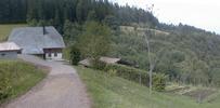
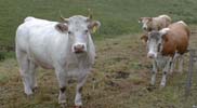
That was quite an interesting excursion. We had been going some distance when we both suddenly realized that it had been a while since we saw our last red diamond. Rather than go back, we decided to see if we could join up with the trail later on. We finally discovered where we were (which was not where I thought) when we came to the Redeckhof farm house which fortunately had its name written on it. Since it was listed on the map (many isolated farms are), we were able to see where we were. The easy way to regain the Westweg would have been to retrace our steps but that didn't seem like an attractive option. So we decided to try a short cut. After a while, however, the path stopped and there was an electric fence barring our way. Since we knew where we wanted to go, we decided to cross the fence and blaze our own trail. We succeeded, but had to go through marsh land, over a stream and across two electric fences. Lots of cow manure to go around as well.


1:00. On a bench above Kalte Herberge. After spending all morning getting lost and then unlost, it's nice to be back on the Westweg. We're stopping here for lunch (rolls from breakfast) and figure we're about half way to Brend. The drizzle has stopped and now it's quite muggy.
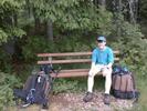
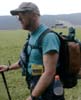
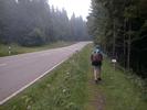
Jacob and I have decided on trail names: "Saftig" (Juicy) for him after his current favorite expression (and his need to drink all the time) and Richard for me (as in Hyacinthe's long-suffering companion, since Jacob, like Mrs. Bucket, always knows better). On our lunch break today, we decided to shoot a some pictures, showing what we're carrying, which are put together below. We've worn shorts and t-shirts every day so far; hat and hankerchief have been very useful. We're using medium-sized internal frame backpacks carrying around 20-25 pounds. Each of us has one side-pack for drinks (holds two 1-liter bottles) with a pocket in which I have wallet, binoculars, candy, cassette player/radio, whistle (for emergency use), knife. We also have another, smaller side pack containing, in my case, a Newt and camera/accessories, as well as passport and travel documents. I also have a "Sherlock" walking stick (collapsible and doubles as a tripod) and a collapsible chair which is the green object sticking out of the backpack (not really necessary here where there are so many benches). The yellow object is the ever-present trail map (one of 7 for this trip). The black object on the back of the backpack is a t-shirt drying (I sweat through 2 or 3 a day).
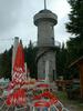
9:00 p.m. Naturfreundehaus Brend. We didn't get here till 5:30, after 9 hours of hiking, much of it uphill and also on asphalt. Much of it went alongside the Schwarzwaldhochstraße, the Black Forest Ridge Road, which roughly parallels the Westweg. It took longer than we had planned mostly because we got lost 3 times. Figuring it out on the map, we went 5 extra kilometers for a total of 23 k. We had to also spend considerable time figuring out where we were.
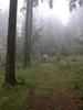
Most of the Westweg is actually marked quite well (red diamond on white background) but at some crucial turns there are no markers-when we saw no sign, we assumed straight ahead, but that wasn't always the right way. It's really essential not only to have a good trail map, but also to follow along as you go so that you know approximately where you are all the time. Most of the path is easily walkable, but sometimes gets muddy or rocky. Much of it is uses logging roads.
By the end of the day Jacob and I were both pretty worn out-the rain didn't help. My blisters have proven to be very painful. Jacob's calves are very sore and he also slipped on the trail over some roots and cut his knee. So we were quite a sight as we limped into the registration area here at the Naturfreundehaus (House of the Friends of Nature).
This is very similar to a youth hostel, inexpensive (30 DM with breakfast) and fairly spartan (make your own bed, use your oun towels). But our room has a private bath and shower and only has the 2 of us in it. There are 3 or 4 Naturfreundehäuser on the Westweg as well as on other marked trails in the Black Forest. Similar are the Wanderheime (hiking hostels) run by the Schwarzwaldherein, of which there are a number along the Westweg.
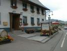
After checking in, we went over to the Brend Gasthaus (the only other building around here) and had Goulashsuppe and a drink (9 DM). The soup tasted great after such a day.
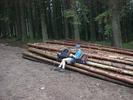
One of our side trails today was through the town of Neukirch. We had run out of all drinks and were looking out in vain for a place to get more. So we headed for this town, only to find that the sole grocery store was closed for its annual vacation. But we found a bakery down the road the had cold drinks. We bought a large bottle of cold weiße Limonade (lemon soda). I can't recall when I've drank anything more refreshing.

